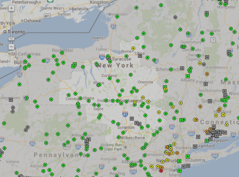
Above: A screenshot from the NWS's river forecast page. Dots indicate USGS streamgauges; the color indicates whether flooding is forecast over the next 48 hours. All gauges in the Catskills region are either green (no flooding forecast) or yellow (near flood stage forecast).
Tropical Storm Andrea is moving northward up the East Coast, bringing heavy rains along with it. But the Catskills region is likely to escape the brunt of the storm's wrath as it passes by to the east of the region.
Although flood watches are in effect for much of the Catskills region through early Saturday, forecasters are not expecting major flooding to be a problem in the area. A public briefing issued by the National Weather Service (NWS) in Binghamton at 11:30am Friday notes that forecasters do not expect major rivers to rise beyond minor flood stage, although some flooding may occur on smaller streams and in frequently-flooded areas.
Andrea is likely to dump one to three inches of rain on the region Friday afternoon and evening. Rainfall from an earlier storm that moved through the region from the west mostly spared the region, falling more heavily in western and north-central New York. Across the Catskills, less than an inch of rain fell in the last 24 hours, according to NWS precipitation data.
Hudson Valley Weather predicts that the rainy weather may clear out by mid-day Saturday -- good news for the thousands of Mountain Jammers camped out on Hunter Mountain, not to mention Livingston Manor's Trout Parade and Delhi's FireFest.
Although major flooding is not expected, the New York City Department of Environmental Protection has been drawing down water from the reservoirs for several days just in case.
According to DEP spokeman Adam Bosch, releases from the Ashokan Reservoir into the Lower Esopus were ramped up from 15 million gallons a day to 325 million gallons a day starting Tuesday, June 4. Both siphons at the Gilboa Dam, which release water from the Schoharie Reservoir into the Schoharie Creek at a rate of 250 million gallons a day each, are currently turned on. Reservoirs in the Delaware system -- the Cannonsville, Pepacton, Neversink and Rondout -- have also been increased to maximum releases ahead of the storm.
Despite the releases, most reservoirs in the system were operating near full capacity as of Thursday, June 6, with the system as a whole holding 99.2 percent of its full water storage capacity. The Schoharie Reservoir, above the flood-prone Schoharie Creek, was the lowest, at 88 percent of its 17.6 billion gallon capacity. Other west-of-Hudson reservoirs were full to the brim: the Neversink at 98.5 percent, the Rondout at 99 percent, the Ashokan at 100.1 percent, the Pepacton at 100.4 percent, and the Cannonsville at 101.3 percent.


